Introduction
Background
More than anything, a street should be a safe space for all. The Capitol Region’s streets are public space, and they should be more than just where we travel—they should be where we gather, play, socialize, celebrate, and trade. For most of history, streets had these many purposes. It wasn't until about one hundred years ago, we stopped prioritizing this variety of purposes, with people at the center, in favor of something more singular: the fast and uninterrupted movement of automobiles.
This plan provides recommendations for reversing that trend through an emphasis on complete streets. “Complete streets” is a term that refers to streets which accommodate all users regardless of mode, age, or ability. More specifically, it provides protected space and accommodations for cyclists, pedestrians of all abilities, native environments/ecosystems, public transit, and the automobile.
As a companion to this plan, the Capitol Region Council of Governments (CRCOG) has developed a regional complete streets policy. This policy makes complete streets a requirement of funding programs administered by CRCOG. It also recognizes that the trend over the past 100 years has been to prioritize the automobile, to the detriment of other users, in effort to reverse this trend.
Broader Planning Context
This plan is a companion to several other plans developed by CRCOG. First and foremost, it provides the underpinnings of the bicycle and pedestrian recommendations in CRCOG’s Metropolitan Transportation Plan, which provides a long-range guide for the region’s transportation system (to 2045). It also responds to the region’s Plan of Conservation
and Development (POCD), which provides a long range vision for land use in the region. Finally, it supports the 2014 One Region, One Future Action Agenda, which fed into the POCD. Complete streets respond to many of the themes in the One Region, One Future plan:
Vision: The Capitol Region will be Connected
Why this is important: Investments in big infrastructure – highways, train corridors, and airports – have created better connections between the Capitol Region and economic markets in Boston and New York. However, the roadway network within as well as between the cities and towns of the Capitol Region is rooted in automobile dependence, lacks affordable options, and is inequitable when it comes to access to opportunity.
How complete streets help: Through this plan, CRCOG will help the economy thrive by funding projects that make streets safer, more convenient, and well-connected for people accessing economic opportunity, whether by foot, wheelchair, bike, train, bus, car, or truck. CRCOG will also facilitate multi-jurisdictional coordination, recognizing that a region of complete streets can only happen through cooperation between member cities and towns, as well as the State of Connecticut.
Vision: The Capitol Region will be Competitive
Why this is important: The Capitol Region’s transportation system helps to attract and retain a highly educated, creative and mobile workforce.
How complete streets help: Complete streets will provide the bones of a competitive region, one that connects residents to educational opportunities, attracts anchor institutions and employers, encourages smart and sustainable development patterns, and leads to the creation of strong, resilient, and diverse neighborhoods. The Capitol Region will build competitiveness from within by proactively investing in communities experiencing poverty, racial inequities, language barriers, and disproportionate environmental and health risks and costs.
Vision: The Capitol Region will be Vibrant
Why this is important: All Capitol Region residents deserve the opportunity to have a high quality of life. Vibrant communities encourage this by offering a variety of cultural activities, active and passive recreational opportunities, plenty of access to natural areas, and interesting places and streets.
How complete streets help: Streets that are safe and favorable for social interaction allow people of all ages, abilities, and backgrounds to live, work, and play in their communities without fear of harm or personal injury. Through a transportation network that equitably accommodates all modes, our region will reap the benefits of livability, public health, safety, affordability, and overall vibrancy.
Vision: The Capitol Region will be Green
Why this is important: Complete streets encourage sustainable transportation modes, decreasing dependence on automobiles and contributing to reductions in harmful pollutants.
How complete streets help: Complete streets will allow the region to maximize sustainability of both the built and natural areas by encouraging smart, compact development and shifting away from automobile dependence.
Trends
Demographic trends in the region also reinforce the need for complete streets. As is described in more detail later, about 10% of households in the region have no access to an automobile. For them, complete streets are an absolute necessity for mobility. In Hartford, the figure rises to 17% citywide and much higher in many neighborhoods. Relatedly, the region is getting older. In 2010, 34% of the region was either over 65 or approaching 65. As people get older mobility becomes a greater concern. While people are living longer, they are not necessarily able to (or want to) keep driving. High quality infrastructure is essential to continue to provide mobility for these populations.
This is an even greater concern for people with disabilities. Over 109,000 people in the region have a disability according to the 2018 American Community Survey. While not all people with a disability have ambulatory difficulties (roughly 50% do), vision, hearing, and cognitive disabilities can also affect mobility. Having safe, high quality complete streets infrastructure can greatly expand mobility.
Action Plan
While the region has made a lot of progress, there is still much work to be done. This time around, CRCOG has many partners it can rely on. More municipalities are actively adopting policies and plans to make complete streets an integral part of their capital programs. The state has also incorporated complete streets into their operations to a much greater degree than in 2008. With stronger partners, CRCOG can take a more focused approach and work on the aspects of complete streets that best fit with the agency’s mission and resources.
CRCOG Complete Streets Plan (Revised 6/28/2021)
2020-0122 CRCOG Complete Streets Policy_FINAL
CRCOG Quick Build Guide (PDF: 28 MB)
2008 Pedestrian and Bicycle Plan
1. Policies and Plans
1. ENACT POLICIES, PLANS, AND GUIDELINES THAT PROMOTE THE IMPLEMENTATION OF COMPLETE STREETS.
1.a. Develop and Adopt a Regional Complete Streets Policy
As the Metropolitan Planning Organization (MPO) for the Hartford Metropolitan area, CRCOG has a unique role in transportation planning. Federal transportation funds that are spent in the region must be approved by CRCOG’s Policy Board. State law also gives CRCOG authority over allocating certain state funding sources, such as the Local Transportation Capital Improvement Program (LOTCIP). CRCOG should develop and adopt a complete streets policy that requires that any project receiving funding through CRCOG must provide accommodations for all users unless an exception is granted. A draft of this policy has been developed for this plan and has subsequently been adopted by the Policy Board. The full policy can be found in the appendix.
The policy requires that all projects receiving funding through CRCOG include accommodations for all users. There is an exceptions process with the following elements:
- Projects where certain users are legally excluded, like controlled-access highways or pedestrianonly streets. Partial exceptions may apply to ensure projects consider all users that are not legally excluded.
- Projects for which there is already a parallel off-road facility, such as a multi-use path. This exception should not lead to an unreasonable detour for users to access destinations along the corridor with the project.
- Projects where no transit routes exist or are planned may be exempt from including transit accommodations.
- Projects where there is no existing or potential/expected demand for a particular user group
- Cost-prohibitive projects. Where a proponent is seeking an exception based on cost, a breakdown of the project cost with and without complete streets facilities is required.
- Where extreme topographical or natural resource constraints, or the need for excessive right-of-way acquisition, lead to disproportionate costs for including complete streets elements, or when there is a compelling reason that a complete streets element of a project must terminate prior to making a logical connection to the existing network for a particular mode.
- Projects where complete streets elements are not consistent with local plans, visions, and/or standards.
The policy also recognizes that different solutions will be necessary in different contexts. Infrastructure appropriate to an urban context may not be appropriate in rural areas. Communities are encouraged to consider how best to accommodate all users in their specific context.
1.b. Assist member municipalities with developing and adopting local complete streets plans
Part of this planning process included a focus on assisting municipalities. The regional complete streets policy included a guide to best practices that will be available on CRCOG’s website. Staff also invited national experts to conduct workshops with municipalities to help them develop local complete streets plans. CRCOG will continue to assist municipalities with drafting local policies as requested.
1.c. Continue to include complete streets considerations in all plans and studies
The regional complete streets policy requires that projects include consideration of all users in every phase, including planning. As has been CRCOG’s practice, staff will continue to include consideration of all users in planning studies conducted by the agency. This includes corridor studies (small area studies) as well as region-wide studies.
1.d. Work with CTDOT to develop a process for ensuring that complete streets infrastructure is included in state-controlled projects
While CRCOG is legally required to be consulted for all federal-aid projects initiated in the region, projects that are funded entirely with state funds do not need to go before CRCOG’s Policy Board. Existing state laws require CTDOT to consider all users in all projects (barring an exception). CRCOG, however, is interested in developing a process to provide greater opportunity for the region to be involved in developing, selecting, and implementing state-controlled projects. An example would include an annual, or semi-annual, consultation process between CTDOT and the regions.
1.e. Evaluate current funding scoring criteria on a regular basis
CRCOG’s current funding scoring criteria for programs like LOTCIP include points awarded to projects that include complete streets elements. The vast majority of projects funded by or through CRCOG are awarded at least some points in this category and projects with strong complete streets elements tend to score well in solicitations. At the start of each solicitation
CRCOG asks its Transportation Committee to review the scoring criteria to ensure they still represent the region’s priorities. Staff should also review these criteria to ensure that they are resulting in the best projects rising to the top. This may involve adjusting the way points are given for complete streets infrastructure. An example would be to revise the scoring criteria in an attempt to differentiate between various qualities of infrastructure. This would have to be done carefully to avoid unfairly punishing projects in locations where high intensity complete streets infrastructure does not contextually make sense.
1.f. Assist municipalities with identifying appropriate guidelines for complete streets infrastructure and ADA accessibility
Traditional design guidelines for highways and local roads (such as AASHTO) do not always include the most up-to-date treatments for bicycle and pedestrian infrastructure. Guidelines like the NACTO Urban Street Design Guide provide a greater menu of options specifically targeted at accommodating all users of the roadway. Often times they include more innovative infrastructure treatments that can result in safer and more comfortable travel for cyclists, pedestrians, and other vulnerable users. CRCOG will continue to provide information to member
municipalities about the availability and applicability of such design guidelines, which are also accepted by CTDOT.
1.g. Work with other local, regional, and statewide stakeholders to monitor and promote effective legislation
CRCOG’s Legislative Committee develops a legislative agenda for the agency every year. This agenda includes a wide variety of topics, but almost always includes topics related to transportation. Through these efforts, the agency also monitors legislation as it is considered by the General Assembly. For important pieces of legislation, CRCOG will provide
testimony in support. Staff will work with the Legislative Committee, and regional partners, to identify legislation that would result in safer streets with greater levels of accommodations for all users.
Where appropriate, CRCOG will provide testimony to support individual pieces of legislation.
2. Complete Streets Network
2. DEVELOP A ROBUST COMPLETE STREETS NETWORK LINKING IMPORTANT NODES OF ACTIVITY THROUGHOUT THE REGION.
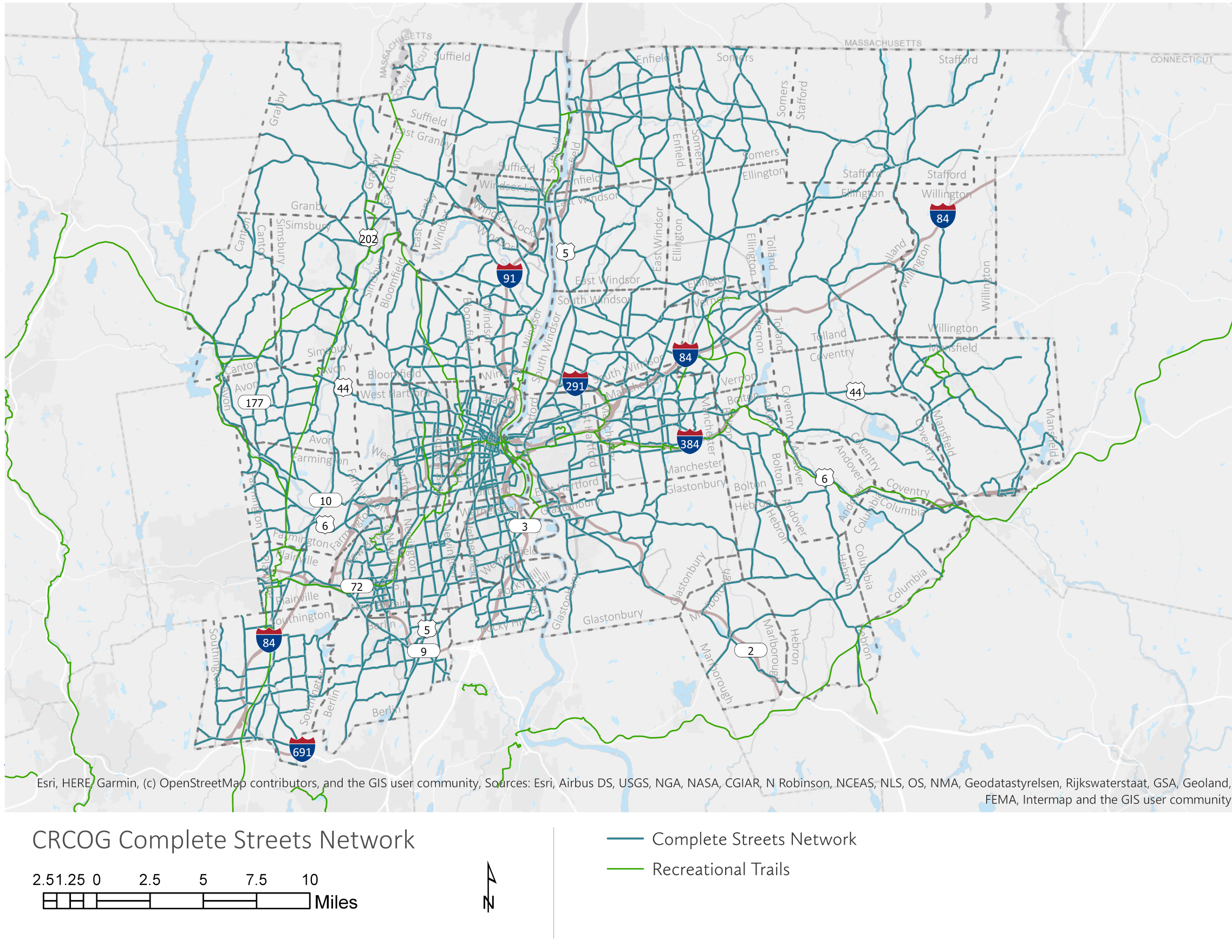
2.a. Implement a regional complete streets network
One of the pillars of this plan is the development and prioritization of a regional complete streets network. While in an ideal world, all streets would accommodate all users, that is unlikely to happen given current funding constraints. Rather than chip away at the road network indiscriminately, the region is prioritizing a network of complete streets that provide connectivity between important job, retail, and housing centers.
The process of defining the network started with a prioritization exercise that asked people which elements of a complete streets network were most important. The top elements were equity (that the network serve those most in need), safety (that it provide safe travel for vulnerable users), and connectivity (that it increase mobility and access).
2.b. Expand the region’s multi-use trail system
The region’s multi-use trail system, having mostly been built on abandoned rail rights of way, weaves through towns and cities. As such, these trails can provide a backbone for the broader network of complete streets. The Farmington Canal Heritage Trail, for example, provides a parallel route to Route 10 that travels through numerous Farmington Valley towns, extending all the way to New Haven. The trails provide a level of safety and comfort (from automobiles) that is difficult to provide on regular streets, especially over long distances. The Farmington
Canal Heritage Trail (FCHT) is nearly complete (one gap remains in Plainville, though a plan has been adopted) as is the Charter Oak Greenway to the east.
Significant trail gaps include:
- East Coast Greenway through Bloomfield and Hartford: currently, there is no east/west trail on the west side of the river.
- Plainville FCHT: this gap closure has been planned but is not yet under construction.
- East Hartford Charter Oak Greenway: this was originally planned to go through Renchsler Field but a new plan puts it on Silver Lane.
2.c. Provide bus and bus rider amenities
Around 4.5% of households in the region rely on public transit. This figure climbs to 15% in the City of Hartford. Amenities for bus riders are unevenly provided. Downtown Hartford has new, well cared for shelters that were installed as part of a larger grant project. Many of the neighborhoods, however, either have no shelters at all, or have shelters that are in disrepair. The same is true of surrounding towns where shelters are few and far between.
CRCOG ran a regional bus shelter program that installed approximately 25 shelters through the region. This program has not received additional funding. A sustainable source of funding for bus shelters needs to be identified. Other areas of the country have entered into agreements with advertising companies to support construction and maintenance of shelters. A similar approach has been tried in the region, but was unsuccessful due to a market conditions. Other
options should be explored.
Upgraded bus infrastructure should also be pursued by the region. Potential improvements could include: bus loading platforms; transit signal priority on bus corridors; increased service frequency; and vehicle electrification.
2.d. Work with municipalities to ensure infrastructure is properly maintained
While CRCOG is legally required to be consulted for all federal-aid projects initiated in the region, projects that are funded entirely with state funds do not need to go before CRCOG’s Policy Board. Existing state laws require CTDOT to consider all users in all projects (barring an exception). CRCOG, however, is interested in developing a process to provide greater opportunity for the region to be involved in developing, selecting, and implementing state-controlled projects. An example would include an annual, or semi-annual, consultation process between CTDOT and the regions.
2.e. Work with the state and municipalities to develop a way-finding system for the region
An aspect of complete streets that is often forgotten is comprehensible wayfinding signage. Signs directing people to and from multi-use trails, transit stops, and local destinations are necessary to create an inviting environment. Some good examples of signage exist in the region. The iQuilt project in Hartford has installed walking focused signs on the backs of pedestrian signals, showing the walk time to various locations. The CTfastrak stations also have consistent aesthetics that make them easy to identify. An integrative and consistent approach will enhance these existing wayfinding systems. This should be done in a thoughtful and deliberate manner, to maximize its effectiveness.
An interactive network map is available here.
3. Educate and Encourage
3. PROVIDE MATERIALS, EVENTS, AND PROJECTS THAT EDUCATE OFFICIALS AND THE PUBLIC ABOUT THE BENEFITS OF COMPLETE STREETS, AS WELL AS ENCOURAGE THEM TO USE AND IMPLEMENT THEM.
3.a. Use “tactical urbanism” to test solutions and educate the public about their benefits
There is no better way to educate people about the benefits of complete streets than to let them experience it. Increasingly, cities and regions are turning to “tactical urbanism”, “quick build”, and other temporary forms of infrastructure as a way of testing out ideas and letting people learn by experience. The basic idea is simple:
- Areas where complete streets interventions are necessary are identified;
- Potential solutions are developed;
- Instead of implementing the solutions with concrete and asphalt, the solution is tried out on a temporary basis with cheap materials, such as paint, cones, and wood;
- Results of the intervention are analyzed and the public is surveyed to determine how effective it is;
- If the intervention is successful, a plan for a permanent installation is developed.
This approach is much lower cost than traditional approaches and allows for a more informed conversation since people will have been able to experience the project before it is fully implemented. Due to the relatively recent nature of this approach, CRCOG has developed a guide to quick build projects that is included in this plan. CRCOG believes that this guide will help member municipalities develop policies and procedures to more effectively use quick build techniques in their communities. The hope is that this will lead to projects being developed more quickly, with greater public input, and with greater acceptance by affected communities. In 2019 CRCOG began work on a CDC-funded project (through the Department of Public Health) to implement demonstration projects throughout the state. Education is also part of the program. Projects have already taken place in Hartford, Easton, Norwich, Stratford, and Goshen. More projects are scheduled for Spring 2020. CRCOG has two years of funding totalling $400,000, with the potential for three additional years.
3.b. Continue to offer educational opportunities to member municipalities and the public
CRCOG acts as both a source of information about educational opportunities, as well as a provider. CRCOG should continue to seek out and disseminate information about educational opportunities regarding complete streets to its member municipalities. Where appropriate, CRCOG should also develop and sponsor educational events for both the public and municipal officials.
3.c. Support educational and awareness programs
In previous plans CRCOG envisioned a more direct role for the region in developing and providing educational materials and programs for the public. CRCOG helped develop elementary school curriculum for bicycle safety and worked with stakeholders to produce pamphlets on safety issues. Local and state advocacy groups have grown since the 2008 plan was developed and they have taken a much stronger role in education. For example, Bike/Walk Connecticut has developed curriculum and offers instruction to both educators and students about bicycle safety. Organizations such as BiCiCo and Bike New Britain sponsor bicycle safety classes. Many schools throughout the region also provide safety classes for students.
3.d. Provide materials for municipal public safety officials and staff regarding applicable state laws regarding bike and pedestrian safety
At CRCOG’s quarterly bike/ped committee meetings, the agenda regularly includes proposals for new or modified laws related to cyclists and pedestrians. CRCOG can partner with Bike/Walk Connecticut to continue this.
4. Monitor Progress
4. MONITOR PROGRESS
4.a. Develop performance targets and measures
As the Metropolitan Planning Organization (MPO) for the region CRCOG is required by federal law to adopt and track performance measures and targets. Currently, required performance measures are limited to safety, emissions, pavement quality, and transit asset management. CRCOG can adopt its own measures and targets if it so chooses.
One suggestion that was received during public outreach for this plan, as well as for the region’s Metropolitan Transportation Plan, is to develop a performance target for reduction in vehicle miles traveled (VMT). While this is not a measure that CRCOG currently tracks (though it does produce estimates of VMT based on its travel demand model) the agency should consider doing so. Reducing VMT is an important way to reduce emissions.
Another measure that could be explored is bicycle ridership. CRCOG has begun doing this through its annual bike/ped count, but there are challenges with methodology. The count is only a sampling of the region and may miss large portions of the region’s riders. Census data, while helpful, is limited to work trips and thus does not capture all bicycle activity. New and improved methodology should be developed in support of this activity.
4.b. Continue to conduct the annual regional bike/ped coun
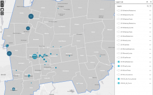
Screenshot of the interactive bike count report.
CRCOG conducts an annual bike/ped count and has done so since 2009. Starting in 2016, the region began a more formalized methodology. Count locations are now put into three groups that are each counted on a three-year cycle. This reduces the burden each year and keeps the set of locations more consistent. Every three years a set of locations can be compared as a time series, giving a better sense of change.
With the 2019 count, CRCOG has it’s first time series data that can be used for comparison. The data was collected in the Fall of 2019 and is currently being entered into a database for analysis. Due to the way the count is conducted, by volunteers using paper forms, the data must be manually entered. Once entered, it is analyzed to reveal any patterns, then added to an online, interactive map.
New technology promises to make the annual count easier, but there are a few significant barriers. The first is scale. The count is done at over 40 locations every year during one or two weeks. Camera based solutions would be expensive to deploy for this purpose as each location would take some setup (the cameras are usually mounted up high) and CRCOG would need enough of them to perform the count in a relatively short period of time. The cameras also need a power source, which can be a battery in some cases, but others need direct power or a solar panel.
The other barrier is the type of information that can be collected with cameras. Generally, they are only good at capturing the raw count. Some are able to differentiate cyclists from pedestrians, but few can reliably identify men versus women. Capturing data on turning movements would be very easy though. CRCOG is continuing to look into these technologies.
4.c. Continue to perform bike/walk audits at key locations and promote the use of the tool by other organizations
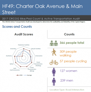
A sample infographic combining audit information with count information.
Along with the bike/ped count, CRCOG conducts audits at count locations. These audits look at walking and biking conditions. They look at physical infrastructure (such as bike lanes and sidewalks) as well as driver behavior. A composite score is calculated for each location. As they are done on a three-year cycle along with the counts, the scores for each location can be compared over a three-year period.
The audit forms can also be used by other organizations or municipalities to conduct their own audits. The forms are straightforward and available on CRCOG’s website.
4.d. Periodically analyze crash patterns to identify priority areas for improvements
As noted below, non-motorized traffic fatalities are on the rise. While the cause of this trend is still being debated, it is important to track the data in a way that allows for priority locations to be identified. Using data from UConn’s Crash Data Repository, CRCOG will continue to analyze and map this data to better understand crash patterns. This information can be used to prioritize projects, or, in some cases, develop interventions with relevant municipalities.
An analysis was completed in 2012.